Historical Markers
around the Great Sacandaga Lake
Page Dedicated
to the Memory of Lewis G. Decker,
Fulton County Historian
who has provided the majority
of information on these Historical Markers
in his book "Road Side History in
Fulton County" published in 1997.
|
| |
HISTORIC
NEW YORK
JOHNSON HALL 1763
Sir William
Johnson (1715 - 1774). Indian Trader, statesman, diplomat
and Colonial Empire Builder. In
1763 built Johnson hall, the center of his estate and the scene
of many Indian conferences.
Coming from Ireland in 1738, Johnson traded with the Indians
and acquired great influence over them.
After defeating the French at Lake George in 1755,
he was created a baronet and made Superintendent of Indian
Affairs for the Northern Colonies. In 1766 he ended the Pontiac
uprising,
and in 1768 negotiated the Treaty at Fort Stanwix.
At Johnstown, which he founded and colonized, Johnson Hall
stands as a monument to his collective achievement.
|
LARGE HISTORIC AREA ROAD
SIDE MARKER, (JOHNSON HAL):
This marker
is self explanatory. The State no longer supplies these cast
metal roadside historic markers to communities but
a few years ago they produced a larger marker to be allowed
at major highway rest areas and scenic overlooks. The only
rest area in Fulton County that qualified was on Route
30 and 29, east of the Vail's Mills intersection of Routes
30 and 29.
This large marker is placed in the woods at this turn off
rest area and is sometimes missed while driving by.
Location: This
marker is on Route 29 east, between the Vail's Mills intersection
of Route 29 east, between the Vail's Mills
intersection of Routes 29 and 30 and before the intersection
of Second Street and Route 29 on the south side in the woods
at the rest area. There is a narrow path up the hill to
the marker. The date on this marker states the year 1961.
|
|
Old Church Grave Yard, Early Dutch Reformed Church:
This
marker directs you to an old burial ground in the wooded
area behind the sign and the site of the 1792 Dutch Reformed
Church. This old cemetery has been abandoned for years and
many of its grave markers have deteriorated. The Mayfield
Historical Society saw fit to mark this site; this being
one of the first installed historical markers in recent years
by the Historical Society. It is located in the town of Mayfield
, the Vail's Mills Settlement. Vail's Mills at one time was
a thriving community in the town of Mayfield.
Location: This
marker is one quarter of a mile pass Route 30, on Route 15
(Extension of West Main Street, Broadalbin) and located on
the North side of 155.
|


|
THE
OLD HOTEL BROADLBIN, A VILLAGE LANDMARK:
This
marker was chosen to be erected by the town of Broadalbin
Bicentennial Committee for the American Revolution in 1976.
The Town Historian then was Lew Cornell. The old Broadalbin
Hotel has been a landmark in the village of Broadalbin since
it was established in 1854 and it has seen renovation through
the years. It served as a hotel, one time as a hospital, a glove
shop and again today (1997) as an inn and dining hall.
Location: the marker is in the village of Broadalbin on W. Main Street
( Route 155), on the south side near the intersection of
Second Street, at the present Hotel Broadalbin.
GPS:
43° 3.424' N, 74° 11.964' W.
More
Info
|


|
VETERANS
HALL
J.B.
McKean post car first met here February 23rd, 1891.
R.L.
Walsh post American Legion first met here September 19th,
1919.
108 years serving America.
Location:
Downtown Broadalbin |
KITTY HUSTED
IN MEMORY OF "MISS KITTY", A
SUMMER RESIDENT, WHO WAS A
MAJOR BENEFACTOR OF
BROADALLBIN IN THE
LATE 1800'S.
|
MARKS
THE SITE OF KITTY HUSTED:
Kitty Husted, "Miss Kitty" as she was known, maintained a
summer residence in the village of Broadalbin. She was active
in local civic matters and beautification of the village and
was one of its benefactors during her residence in the late
1800's. The Broadalbin Historical Society , along with the
town historian, Mr Jay Nellis, chose to honor her memory in
1994 with this historic marker which was erected at the site
of her summer home.
Location: Take route 155 ( W. Main Street) into the village of Broadalbin,
turn north at the village square (monument) on
to North Main Street, then veer to the right, this becomes
North Street ( route 117). Proceed one block and take the first
street on your right ( Maple Street). The marker is three
doors down on your left from Thompson St. intersection (north
side).
More
about the Broadalbin Husted Family
|


|
THE
SITE OF THE HOME OF ROBERT W. CHAMBERS:
This
historic marker is placed at the entrance of the old Robert
W. Chambers home, which now in 1997, is the rectory house
for St. Joseph's Catholic Church. Robert W. Chambers was
a well known author of his day and resided here in the
village of Broadalbin. He is noted for the numerous novels
he has written, some of which have a local historic background.
Chambers was an illustrator as well and known as a local
amateur entomologist. This marker was erected in 1976 during
the Bicentennial of the American Revolution and dedicated
through the effort of the Fulton County Bicentennial Coordinator,
lewis G. Decker and the Town Supervisor, Mr. Robert Leslie.
Location: This marker , located in the village of Broadalbin, is
at the gate 9entrance) to his old estate, just a few feet
from the intersection of N. Main and North Street (route
117) on the North side.
More
About Robert W. Chambers
|
NICK STONER HUT
HERE HENRY STONER AND HIS
SONS NICK AND JOHN HELD THE
CABIN AGAINST THE TORY AND
INDIAN RAIDERS WHO BURNED
BROADALBIN, JUNE 1778
|
HENRY STONER"S HOME:
This marker
is unique as it is in the Town of Mayfield, although you
have to travel through the Village of Broadalbin to reach
it. it had been destroyed years ago and for years only the
post was left. The Mayfield Historical Society recently took
the initiative to replace this sign. The actual site of John
Stoner's cabin was just behind this marker (east). It is believed
that the log cabin had no foundation. John Stoner was killed
during the war for independence at a temporary farm site he
was occupying during that war, out by F.M.C.C.. His son Nicholas
became famous in later years after the war and many local stories
have been written about him. The present marker was copied
word for word, from the original. You can find some interesting
stories on the Stoner Family in Donald William's books, "The
Saga of Nichols Stoner" and "Nicholas Stoner and the Sammons
Boys"
Location: Take West Main Street in the Village of Broadalbin
and turn north onto North Second Street. The marker is on the
east side of the road, shortly after you cross the town line.
The original marker was suggested by Robert W. Chambers and
installed in 1932.
|
|
LOCUST
GROVE
1805 Home of Col. Tiffany Brockway.
War of 1812 veteran abolitionist. Used as a stop on the
underground railroad for fugitive slaves going North.
Location: Route 30 Broadalbin
"Tiffany
Brockway came to previously purchased lands northeast of
Fonda’s Bush in 1791 at the age of seventeen. Here
he built a log house, made a clearing, and sowed a field
of wheat, welcoming his father, Nathan, and family to their
new forest home on his 18th birthday, March 6, 1792. On April
11, 1799, he was married to Lucy Alvord and in 1805 located
on a farm near his father’s, afterward known as Locust
Grove, where he remained till his death. He was a major in
the war of 1812 and for many years following was a colonel
of militia. Industrious, economic, temperate, integral, he
was the first pronounced abolitionist in the town. At the
advanced age of sixty he united with the Broadalbin Baptist
church, living through many more years of a vigorous and
useful old age, and passing away on Dec. 3, 1866, still rejoicing
over the achievement of his fondest hope for the slave."
The
above excertp came from A Broadalbin History by By R.
J. HONEYWELL and was contributed to Fulton
County NYGenWeb by James
F. Morrison, from his personal historical collection.
It was transcribed for the web site by Lori Mosher. Read
More Here
|


|
FRENCHMANS
CREEK
This
marker designates a place name given to a tributary or
creek that empties into the Great Sacandaga Lake. The creek
derived its name from one of the areas early pioneers,
a Frenchman by the name of Joseph De Golyer who first settled
on its banks when it was but a wilderness. By 1810 Duncan
McMartin had established a saw, grist and woolen mill on
this creek. McMartin was known as a surveyor, lawyer and
judge of common plea by 1813 and later became elected as
a State Senator.
Location: This marker is located on the south side of Route 110, north,
out of the village of Broadalbin where the creek crosses
the highway.
|


|
HANS'
CREEK :
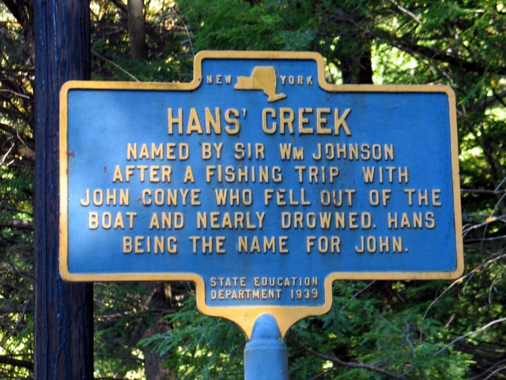
This marker also designates a place in the northern portion
of the Town of Broadalbin which is one of the tributaries
emptying into the Great Sacandaga Lake. It was so named by
Sir William Johnson on one of his many fishing excursions
on the old Sacandaga Vlaie. An incident occurred when a fishing
companion od Sir William, a Dutchman by the name of John
Conye, fell out of the boat they were fishing in and nearly
drowned. Hans was derived from the German version of the
name John.
Location: This marker is located north on Route 110, beyond the settlement
of North Broadalbin and near the settlement
known as Benedict Corners. Here the road makes a turn and near
by Hans Creek crosses. ( Note: this maker is somewhat hidden
by the trees around it. It is located on the south side of
the road by the creek.)
|
|
MARVIN
HOUSE:
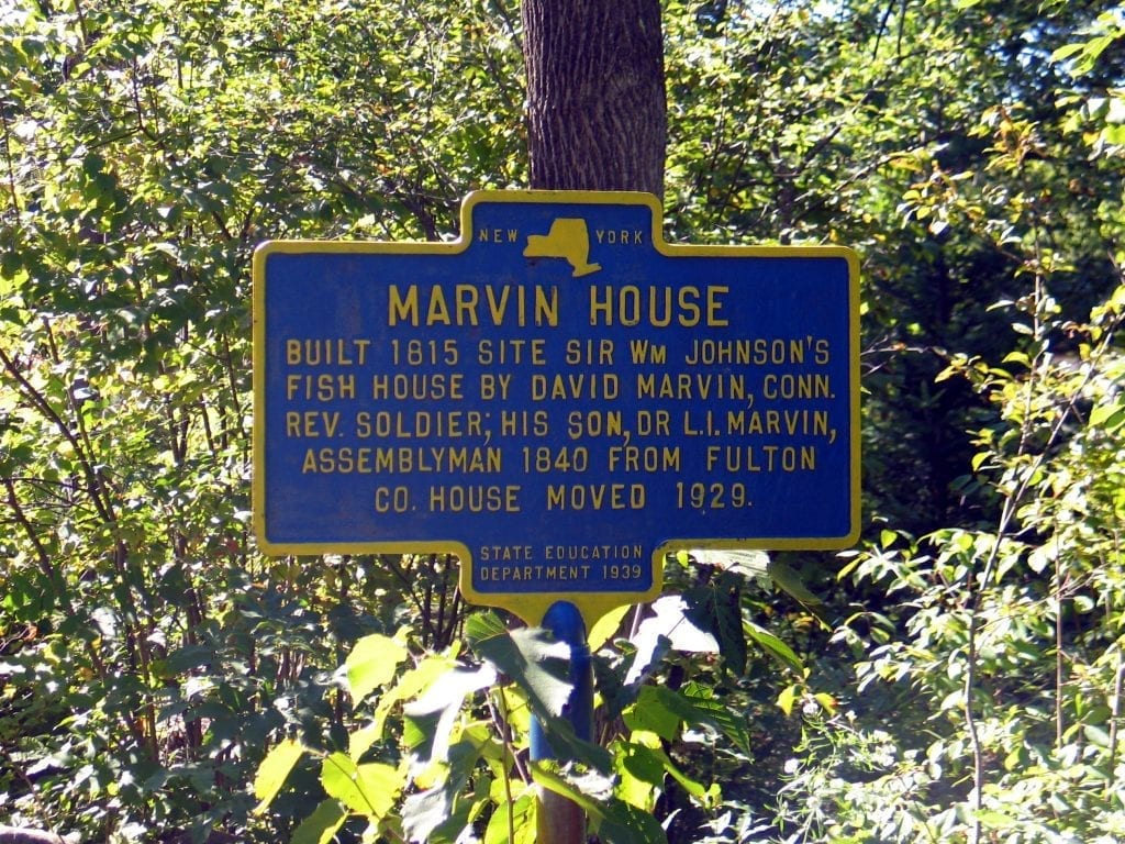
The
old Marvin Home was one of the community's older homes.
David Marvin was a Revolutionary War soldier and one of
the early settlers of old Fish House; after the war he settled
here from Connecticut. David is buried in the old Presbyterian
Church Grave Yard in the hamlet of Fish House The Marvin
Home survived the flooding of the Great Sacandaga Reservoir
and was moved to this later location in 1929. This old home
was left-in-tack until 1996, when it was purposely burned
to the ground. This caused concern in the neighborhood and
a special meeting was held to see if the rest of the old
homes here could be protected. Dr. Marvin's office is a small
brick structure used today as a summer camp and located just
up the road from this marker.
Location: As you enter the Fish House Hamlet, this marker is on the
north side of Route 110 and west of the intersection of 109
and 110.
|


Old
Fish House Hotel
|
SIR
WILLIAM JOHNSON"S FISH HOUSE LODGE
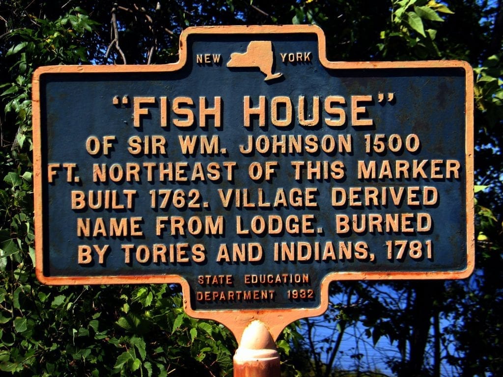
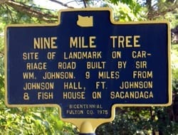
This historic
roadside marker directs you to the site of the hunting
and fishing retreat which Sir William had built
on the old Sacandaga River as early as 1762 and was known
as his "Fish House". Others began to settle here
and this little settlement became known as the Fish House
settlement.
Originally named Northampton, no one ever called it that;
and years later the name was changed officially to Fish House.
The original fish house lodge of sir William was believed
to have been destroyed in one of the raids in 1781, during
the American Revolutionary War.
Location: this marker is located in the hamlet of fish house,
on the north side of route 110 (the Broadalbin to Bachelorville
road) and across from the intersection of route 109 ( the
road south to Hagadorn mills).
|
|
OLD
COVERED BRIDGE AT FISH HOUSE:
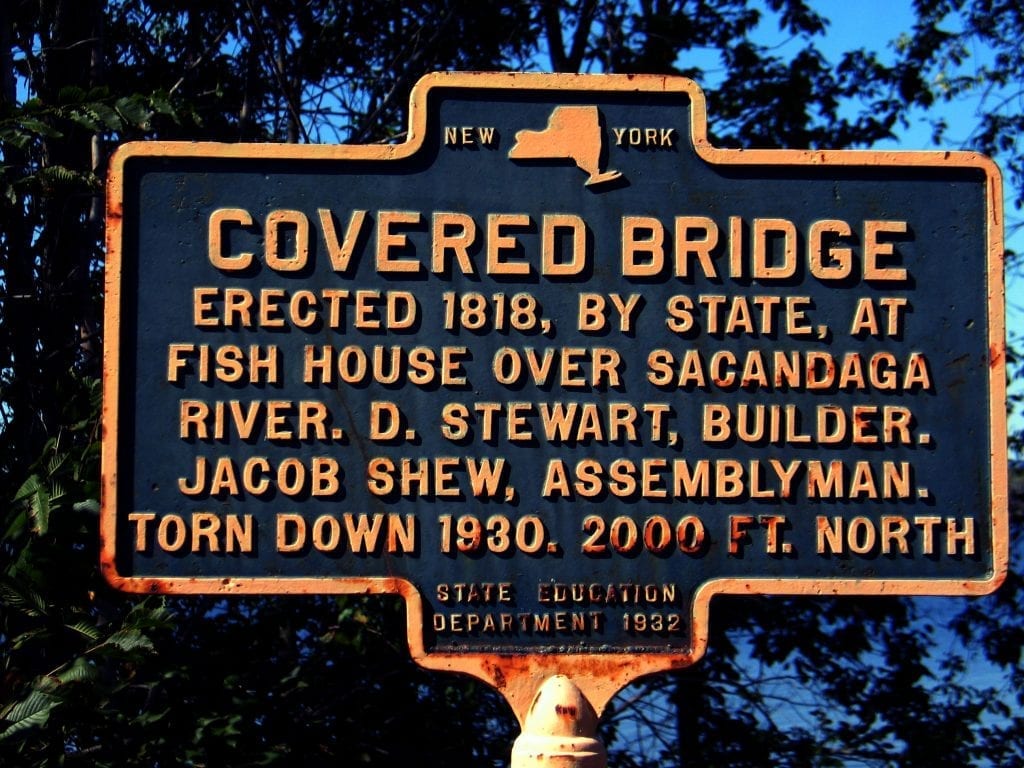
This
old covered bridge passed way during the construction
of the present day Great Sacandaga Lake It connected this
portion of the Town of Northampton with the rest of the
northern town.
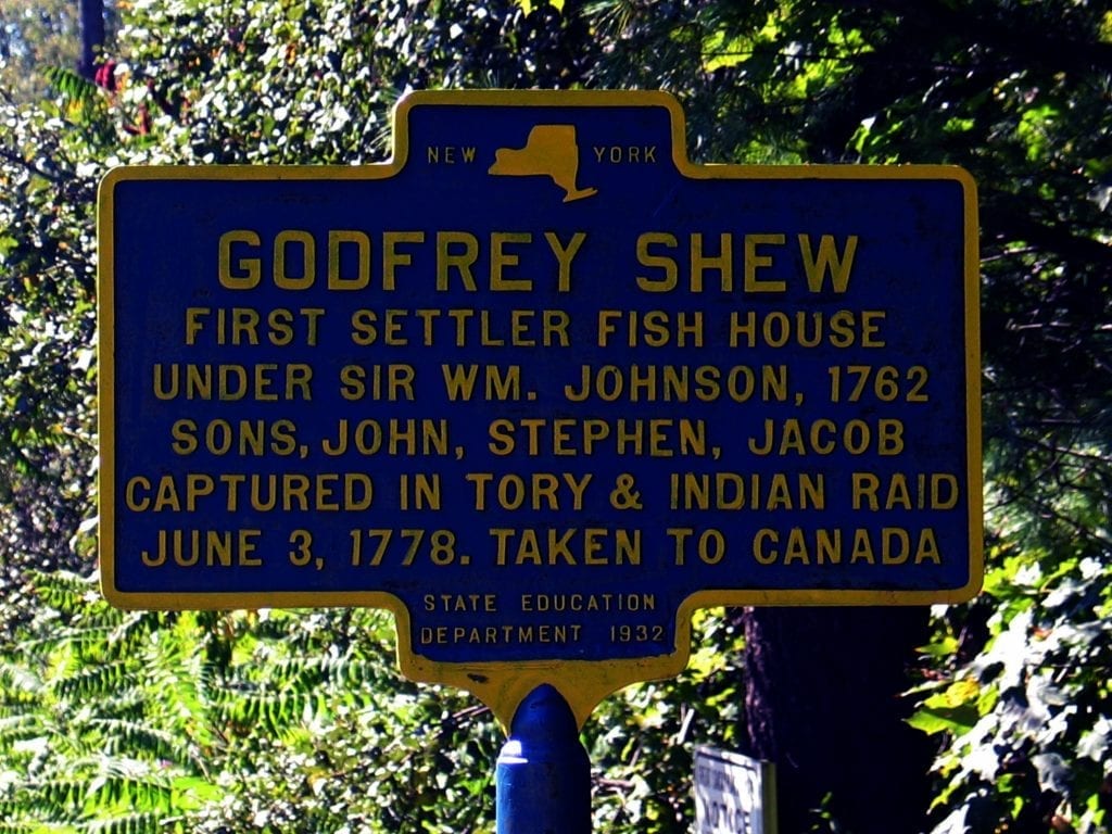
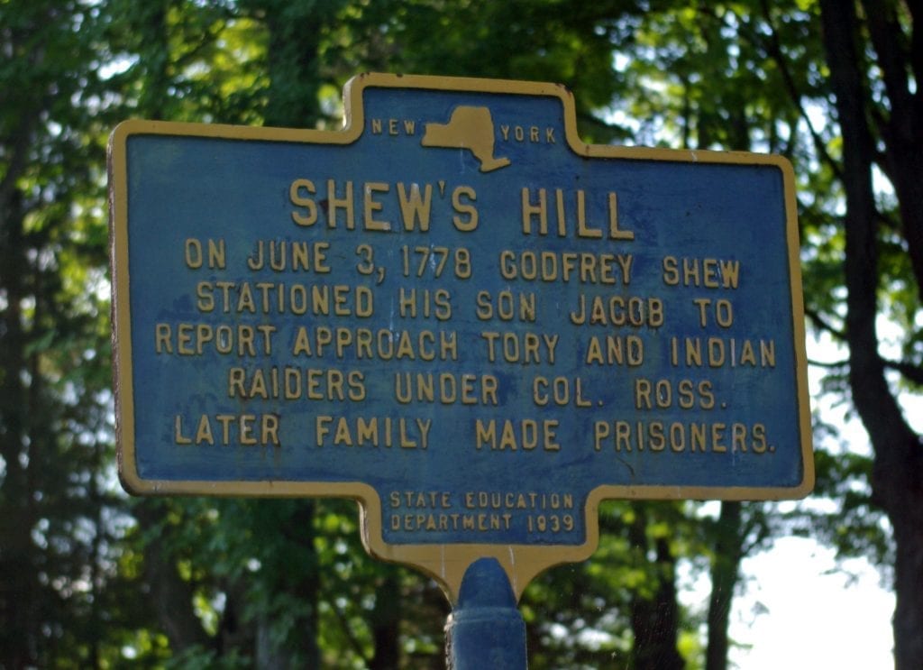
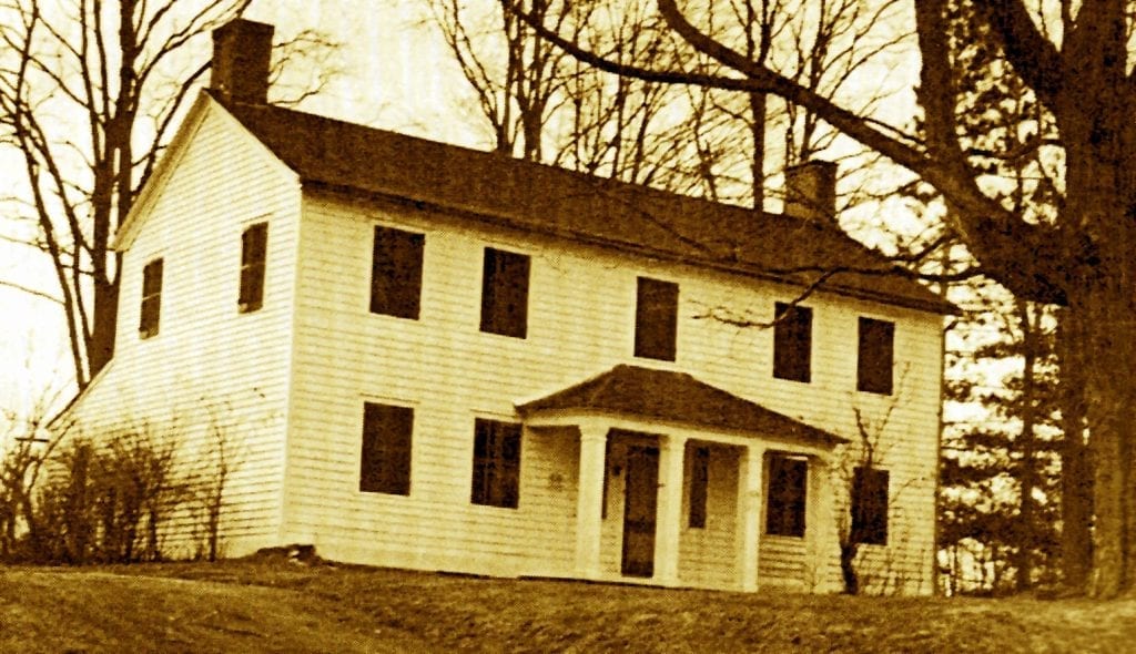
 Today the Hamlet of Fish House is isolated
from the rest of the Town of Northampton. This old bridge
was a local landmark and well remembered by our older residents.
There was an attempt to save this old landmark but it was
destroyed in 1930. Location: This
marker is at the intersection in the Hamlet of Fish House
on Route 110, on the north side, across from the Route
109 intersection.
"The
Fish House bridge was built in 1818, by Daniel Stewart.
The then wide awake spirit of the little hamlet
known as Fish House, and the rich farming country lying
beyond, together with the prospect of Fish House being
one day the great center of trade for this northern
region, incited the dwellers therein to use every effort
in their power to realize their hopes. The inhabitants
petitioned the legislature for and received an appropriation
of $5,000 for the building of the bridge. To this the
citizens added by subscription $500. The bridge is
now in the best possible condition, well covered and
protected from decay. Before it was built, the Sacondaga
was crossed by canoe and by fording. During the spring
and fall freshets the people were very much inconvenienced,
as they could not cross with teams, and many times
it was unsafe for canoes. The old ford was from a few
rods below where the south end of the bridge now is,
to a short distance above the north end."
The
above history was taken from: "History of
Montgomery and Fulton Counties, N.Y.", (New York:
F. W. Beers & Co.) 1878, page 233. was
contributed to Fulton
County NYGenWeb by
Stephan G. Dennie
Read
more about Covered Bridges in the Sacandaga Valley
Here
|
|
GODFREY
SHEW ORIGINAL HOME SITE
This
marker designates one of the early settler's homes, in
the Town of Northampton. There have been amazing stories
of Godfrey's sons and their exploits during our fight
for independence. The old Sacandaga River was a main artery
from the east to the Hudson and the Champlain Corridor
and many raids into the Mohawk Valley used this route through
this river system and traveled by canoe. Those living along
it were isolated and vulnerable to these raiding parties.
Mr. Donald Sawyer wrote a wonderful book on the Shew Family
titled, "They came to Sacandaga".
Location: This marker is located on the north side of Route 110,
in the Hamlet of Fish House at the Saratoga County boundary
line.
More
about the Shew's of Fish House from Fulton
County NYGenWeb
|
Photo
Submitted by Sacandaga Calendars!

Photo
Submitted by Sacandaga Calendars!
More
about the Shew's of Fish House from Fulton
County NYGenWeb |
SHEW'S
HILL: ON
JUNE 3, 1778 GODFREY SHEW
STATIONED HIS SON JACOB TO
REPORT APPROACH TORY AND INDIAN RAIDERS UNDER CO. ROSS.
LATER FAMILY MADE PRISONERS.
IF you
read the exploits of the Shew family of old Fish House, they
mention a high rise of ground overlooking the Sacandaga
River; it became a good location to see anyone passing up or
down the river. During the many aids down the Sacandaga during
our American Revolutionary War, Godfrey Shew used this location
to station one of his sons, to forewarn them of any approaching
enemy. It has ever since been known locally as Shew's Hill. The
Fish House (Northampton) Cemetery is located here as well and
the Home of Doctor Orton, an early physician in the town. His
son, Percy Orton, was instrumental in suggesting a number of
these markers in the hamlet.
Location: this marker is located in the Hamlet of Fish House, on the
north side of a short dead end road off Route 110. It
is the first road pass the intersection in the hamlet of Fish
House ( Rout 110 and 109). Turn off Route 110 by the Methodist
Church, proceed down the dead end road, and it is just a
short way down on the north side of the road.
"Early
in the morning of June 3rd, Woodworth with Godfrey and John
Shew left the house in order to find the enemy's whereabouts.
Jacob and Stephen stayed behind to guard the house. After traveling
some distance, the scouting party was surprised and taken prisoners
by a party of Indians under Lieutenant John Ross. They were
taken to the enemy's nearby encampment.
Jacob who had been stationed on a knoll near the house that
overlooked the nearby Sacondaga River, saw a canoe coming down
the river and he ran back home to inform his mother about the
presence of the enemy that came from another direction.
The Shew home and barn were set on fire leaving Mrs. Shew
with her small children homeless. The enemy took Jacob and
Stephen to the main encampment where the other prisoners were
held. Mrs. Shew with her children started Johnstown and they
arrived there on June 4th.
On
December 1st, Jacob with his father and brother with other
prisoners
were put on ships and taken to Boston where they
would be exchanged for prisoners held by the Americans. The
Shews on being set free started on their long journey home.
On reaching Sudbury about twenty miles from Boston, Jacob took
sick with small-pox. Jacob was left with a Patriot family to
be cared for. Godfrey and Stephen continued on their journey
home and they reached Johnstown on January 1, 1779, New Year's
Day. Jacob arrived at Johnstown cured of the small-pox on March
17, 1779, it being St. Patrick's Day."
The
above is transcribed from pages of the book, Fulton
County in the Revolution By James F. Morrison and
typed by dedicated volunteer, Peggy Menear for Fulton
County NYGenWeb
Read More Here |
| 

Photos
Submitted by Sacandaga Calendars!
|
THE
ST. JOHN HOUSE:
This
is one of the older homes, in the Fish House Settlement,
still existing today Among other things, Alexander St.
John was a surveyor and engineer. He is credited by some
historians as having the village and town of St. Johnsville
named after him. He became one of the town's leading citizens
and is buried in the Fish House Cemetery, not far from
his old home. This old home in Fish House, like others
here, should be preserved; they are some of the oldest
homes in our country.
Location:
This
marker is located in the Hamlet of Fish House on the north
side of Route 110, just past the intersection
of Route 109.
|
|  SHEW HOUSE
BUILT 1784 BY GODFREY SHEW
AND HIS SONS JOHN, STEPHEN
AND JACOB AFTER THEIR RETURN
FROM CANADA AS PRISONERS OF
COL. ROSS ON JUNE 3, 1778 |
OLD
SHEW HOME:
This old
home in the hamlet of Fish House dates back to 1784 and is
considered
one of the oldest in the town of Northampton.
The original home had been destroyed during the raids through
the area during the Revolutionary War. This home is one of
the few existing 18th century homes in the town of Northampton.
If you would like to find more information on this early Fish
House Families, see Donald Sawyer's Book, "They came to
see Sacandaga".
Location: This marker is located on Route 110 in the hamlet
of Fish House, on the south side of the road in the front of
the old home. This is the last house in the hamlet before you
cross the Fulton County line into Saratoga County.
|


|
ANDERSON
CEMETERY:
Location: right next to the I-Go-Inn
on South Shore Road.
|


|
FIRST
SCHOOL
Town's first school built on this
site on land given by Jonathan Anderson. Earliest district
in town settled in 1787. Located on South Shore Road in
Edinburg.
Location: |


|
BATCHELLERVILLE
Presbyterian church erected in 1867,
moved to present site in 1930 to escape the rising waters
of the Sacandaga Reservoir.
Location: South Shore Road, Edinburg
GPS:
43° 12.551' N, 74° 4.893' W.
More
Info |


|
GREAT
SACANDAGA LAKE
Created in 1930 as the Sacandaga Reservoir.
Ten Communities were lost to the rising Waters
Location: South Shore Road, Edinburg
|


|
OLD
COUNTRY STORE
Built in 1875 on west side main street
opposite FOx Hill Road by Faulkner Noyes and Charles Wait.
At times a Post Office. Moved to it's present site c. 1929
Location: South Shore Road, Edinburg
|


|
BATCHELLERVILLE
On
this site was located the historic village of Batchellerville
inundated in 1930 by the Sacandaga
Reservoir.
Location: South Shore Road, Edinburg
|


|
Location: |


|
BEECHER
HOLLOW
Methodist Church built in 1836 due
to strong influence of early Beecher Hollow settler Jesse
Barker II. A revolutionary War hero.
Location: Edinburg Four Corners.
|


|
TOWN
MEETING
First town meeting held on this site
March 13th, 1801 at the home of James Goodwin. Town named
Northfield name changed to Edinburg in 1808.
Location: Edinburg Four Corners.
|


|
BEECHER
HOLLOW
Historic hamlet settled in 17'90's
along the banks of Beecher Creek. Now the site of Nellie
Tyrrell Museum
Location: North Shore Road Edinburg
|
|
BEECHER'S
STORE
Early Stage Coach Stop and Site of
town's first post office. Original house built c. 1802.
Post office moved to Edinburg 4-Corners in 1948.
Location: Just off North Shore Road, Edinburg
GPS:
More
info |

Barker's
Store & Sumner Home 1847
Cortesy
of The Edinburg Historical Society
|
BARKER'S
STORE
Built in 1847 by John Barker, operated
continuously as a store until 1945. Believed to be a stop
in the underground railroad.
Location: Just off North Shore Road, Edinburg
GPS:
43° 13.291'
N, 74° 6.23' W.
More
Info
|
|


|
CARRIAGE
SHOP
Erected
prior to 1828, Arad & Leonard
Copeland operated the water-powered shop. In 1884 converted
to machine shop by John W. Latcher.
Location: North Shore Road, Edinburg
GPS:
43° 13.247' N, 74° 6.095' W.
More
Info |


|
COVERED
BRIDGE:
Built by Arad Copeland below Beecher
Falls in 1879. Only NYS Queenpost Truss bridge. Placed
on NYS and National register in 1998.
Location: North Shore Road, Edinburg
GPS:
43° 13.258' N, 74° 6.021' W.
Arad
Copeland (1805-1884) came with his family from Guilford,
Vermont
to the Sacandaga Valley in 1815, first settling in
the Town of Day. In 1828 Arad and his brother Leonard moved
to the Town of Edinburgh, purchasing Ely Beecher’s
sawmill and carriage factory located along Beecher Creek.
Arad
married Anna Elizabeth Trowbridge, daughter of Edinburgh
resident Willard
Trowbridge.The Trowbridges’ operated
a brick kiln behind their home on what is now Sinclaire road.
As a wedding gift Willard donated the bricks for a house
and Arad built the home for his bride c.1832. The house still
stands today across the road from the covered bridge.
Arad had 35 acres across Beecher Creek where he had garden and pasture land.
An open bridge below the house gave access to this acreage until it was destroyed
by melting spring snow and ice. In 1879 he then decided to build the covered
bridge that still stands today. According to family legend local residents
Melzor Manning laid the stones, Jacob Latcher hewed the timbers and Azariah
Ellithorpe Jr. framed the bridge.
Over
the years the bridge received a new metal roof, new flooring
and
some side boards were replaced. The bridge is
35 feet long and is New York State’s only queenpost
truss. A popular tourist attraction the bridge has been photographed
from all angles, painted by visiting artists and even played
host to a few wedding ceremonies. The only covered bridge
left in Saratoga county it has always been used for animal
and pedestrian traffic.
Arad had 35 acres across Beecher Creek where he had garden
and pasture land. An open bridge below the house gave access
to this acreage until it was destroyed by melting spring
snow and ice. In 1879 he then decided to build the covered
bridge that still stands today. According to family legend
local residents Melzor Manning laid the stones, Jacob Latcher
hewed the timbers and Azariah Ellithorpe Jr. framed the bridge.
More
Info
Cortesy
of The Edinburg Historical Society -
Read
More Here
Read
more about Covered Bridges in the Sacandaga Valley Here
|


|
FIRST
HOUSE BUILT IN OLD NORTHVILLE SETTLEMENT:
This
marks the site of an early settler's home, Samuel Olmsted.
located in what is today the village of Northville. Samuel's
gravestone is just up the street in the old Northville
Village cemetery, next to the gate entrance which denotes
him as the first settler. This marker was installed in
1976 during our country's American Revolution Bicentennial.
Location: This
marker is on the South Main Street in the Village of Northville,
pass Van Arnam Street on the west side.
|


|
NORTHERN
MOST TERMINAL OF THE F. J.
& G. RAILROAD:
This marker
designates the site of the Northville Depot, marking the
northern most extent of the old Fonda, Johnstown, and Gloversville
railroad line. In the fall of the year, when waters of the
Great Sacandaga recede, you can see the old foundation of this
station which was located behind this sign, over and toward
the old river bank. A special committee was set up in the country
during the American revolution Bicentennial, which was comprised
of railroad enthusiasts from Gloversville, Johnstown and Northville,
who agreed this site should be marked. They put on a special
exhibit in the Northville School Cafeteria along with the dedication
that day in 1976. The photograph of this dedication and committee
can be found in "The History of Fulton County" by Lewis G.
Decker, as well as other pictures of other town dedications.
This marker in addition notes the amusement park that was near
and was run by the F.J. and G. Railroad.
Location:
the original location of this marker was on the
southeast corner of the intersection of Route 30 North
and the entrance
to the Northville Bridge and Village. When the new bridge
was built and the intersection widened, the sign was relocated
where it is today, on the northeast side in a small park.
GPS:43° 13.439' N, 74° 11.066'
W
More
Info
|


|
ADIRONDACK
INN
Built
in 1891 by the FJ & G RailRoad
conspired the gem of the Sacandaga Park this ornate wood
structure burned in 1975.
Location: McKinley Road - Sacandaga Park
GPS:
43° 12.968' N, 74° 11.258' W.
Regarding Adirondack Inn. "...A
short distance from the railroad station is The Adirondack
Inn, one of the finest
summer resort hotels in America, accommodating
By Howard C. Ohlhous, July 1, 2008
250 guests. The halls and rooms are provided with steam heat,
and the hotel grounds lighted by electricity, presenting
at night a picture of a veritable "Fairy Garden." Guests
may secure rooms single or en suite, with or without a private
bath. The house is tastefully decorated and richly furnished,
and the conveniences of the telegraph, the telephone, and
a prompt postal service are among the privileges enjoyed
by its guests. Balls, House Parties, Automobiling and Coaching
go to make up a part of the pleasures at this up-to-date
hostelry. The roads along the Mohawk Valley, passing through
Schenectady, Amsterdam, Johnstown and Gloversville, enroute
the Sacandaga Valley, are particularly good for automobiling.
The Adirondack Inn is ably managed by Mr. C. O. Chamberlin,
to whom applications for rates and rooms should be addressed."
Source: "1906 Summer Outings Sacandaga Valley; The Pleasure
and Benefits of a Few Weeks of Leisure Spent Among the Beautiful
Resorts of the Adirondacks," Published by Passenger
Department, Fonda, Johnstown & Gloversville Railroad"
In the early 1890s many short line railroads
were building amusement parks as a way to increase rail
line patronage.
In 1891 the Fonda Johnstown & Gloversville (FJ&G)
purchased thirty-five acres of land near the end of its Sacandaga
Line and made it into a summer resort called Sacandaga Park,
and built the
More
Info
|


|
KING
CEMETERY:
This is
the site of an early cemetery in the Town of Northampton
and the marker credits Henry King
as an early settler in this portion of the town. The cemetery
contains graves from sites which were removed during the
flooding of the Great Sacandaga Lake. Note the grave of Jason
Bacon
and Civil War Soldier, Tring
Location: This marker is on Old Route 30 ( today Route 152),
just north of the Houseman Street intersection and SOuth
of Sacandaga Park, on the west side of Route 152.
|
| WOODWORTH
FARM CONVEYED
BY COMMISSIONERS
OF FORFEITURE TO WILLIAM G.
WOODWORTH IN
1786. SERVED IN
REVOLUTION. PASSED TO HIRAM
WOODWORTH 1810-1910. |
SITE OF OLD WOODSWORTH FARM:
The Woodsworth
family were early settlers in the town of what is today Mayfield,
and they played an important part in the American cause for
our independence during the American Revolution. The property
that
this sign refers, was procured by one of the Woodsworth sons,
William G. Woodsworth, where he settled after the Revolutionary
War. As the marker states, it was passed on to his son Hiram
who owned the farm from 1810 to 1910 and it was known as the
old Woodsworth Farm. The marker was installed in 1936 and suggested
by E. J. Ruliffson, an early Mayfield Historian. (Note: In
the Town of Bleeker, over the mountain behind this area,
is Woodworth
lake, named after this family and until recent years used as
a boy Scout Camp)
Location: This
marker is located on Phelp's Street ( Route 102) near Riceville
side. Take Route 30A north until you come to the
Phelps Street intersection. Proceed west on Phelps Street ( Route
102) and you will pass the Mayfield Grange Hall and marker will
be just around the corner on the north side of the road.
More
about the Woodsworths from Fulton
County NYGenWeb |

Tintype
Photo of William C Brower SR (1843-1925)with his sisters
Elizabeth (1841-?) and Lucretia (1840-1873). Photo taken
approx. 1862. Note private stripes on the sleeve of his
uniform. William served in the 10th NY Cavalry Co I. More |
HOME
OF WILLIAM BROWER, INVENTOR:
ON
THIS SITE IN
1916 WM C BROWER INVENTEDAND PATENTED THE FIRST SAP GRAVITY FLOW TUBING SYSTEMFROM
TREE TO SUGAR HOUSE FOR MAKING MAPLE SYRUP.
On this
farm site was the home of William Brower who is credited
with first introducing the use of tubing by gravity, making
the maple sap flow from the Maple Trees, which in turn makes
maple sugar. William as well has been credited in coming up
with some other remarkable ideas in his day. The Mayfield
Historical Society, along with the Town of Mayfield, saw it fitting
to give him recognition by dedicating this marker in 1993. Location: This marker is located on the road called the "Mountain
Road" Route 123, north off route 30. It is located on the south
side and approximately two miles up the Mountain Road. It was
installed 1993.
|
|
WOOSWORTH BURRYING GROUND:
This marker directs you to the burying ground of early settlers,
but was used by the Woodsworth family. This cemetery was on
part of the Woodsworth Farm and near by at the crossroad, is
what is called Woodsworth Corners The Woodsworth's played an
important part in the American Revolution from old Tyron County.
This marker was installed in memory of this historic family
in 1936. (Note: Near by and on the same side of the road, is
believed to be an early burial ground for the Quakers who had
established a Meeting House which was located on the opposite
side of the road in early 1800's both of which should be marked
some day in the future)
Location: Take (Route 146), West Main street Extension (west),
off Route 30A north; the marker is on the north side of the road,
just before the crossroads of Jackson Summit Road and old Route
30.
|


|
AMASA
STEPHEN
Was
Murdered near here by Sir. John Johnson and his loyalist
and indian allies May 22, 1780
raid. Early settler and Patriot.
Location:
On May 22nd, Colonel Sir John Johnson with about 500 Indians
and Loyalists were in the Mohawk Valley burning and killing.
Just about dawn the enemy appeared at the Stephens home.
They broke the door in and immediately headed to where the
Stephens were sleeping. The Indians dragged Stephens from
his bed and took him outside. On reaching outside the Indians
tomahawked and scalped Amasa and then hung him on the fence
near the house. The enemy then plundered the house and then
left without harming Mrs. Stephens or her children.
After the enemy left, Mrs. Stephens went looking for her
husband and on going outside she discovered him hung on the
fence. She took him down and took his body back into the
house. Mrs. Stephens immediately grabbed her two children
and headed for Fort Johnstown and she arrived there a few
hours later. On arriving at Fort Johnstown Mrs. Stephens
met her mother and learned that her father and brother were
killed.
The
above is transcribed from pages 39-49 of the book,
Fulton County in the Revolution By James F. Morrison and
typed by dedicated volunteer, Peggy Menear for Fulton
County NYGenWeb
Read
More Here
|
BURYING
GROUND
OF MAJOR HARMON AND
FRANCIS VAN BUREN SEVENTH
ALBANY COUNTY REGIMENT;
REVOLUTIONARY WAR.
SETTLERS ON THIS
LAND. |
THE BURIAL SITE OF TWO REVOLUTIONARY
WAR VETRANS:
This marker directs you up a narrow dirt road that leads to
some summer camps. In the yard of one of these camps is a boulder
with an inscription to two Revolutionary War Soldiers buried
here; Major Harmon and Francais Van Buren, who had settled
here after the Revolutionary war and who had served in the
Albany County Militia. In seeking this site I would ask you
to use caution and courtesy as this grave site is on private
land.
Location: This
marker is located on the old Vanderburgh Point Road east
off Route 30. Follow Vanderburgh Point Road and just
past the intersection of Perique Road (known locally as Perique
Corners), you will discover this marker on the north side of
the road just before you reach Vanderburgh Point, the Beach and
the Sacandaga Reservoir.
|

|
RICEVILLE
CEMETERY: HERE
ARE BURIED JONATHAN FISK - OLIVER RICE - WILLIAM WOODSWORTH
-
SAMUEL WOODSWORTH - JESSE FOOTE -ISAAC BEMIS - JONATHAN CANFIELD -
SOLDIERS OF THE REOLUTION
This old burial ground in the town of Mayfield marks
the graves of several old settlers and veterans of the American
Revolution. (Note: there is a glacial boulder placed in front
of this cemetery with an attached bronze marker which gives
notice of the revolutionary war soldiers buried here).
Location: This
marker is in front of the cemetery on the north side of old
Route 30 (Riceville Road), just south of old Route
30 (Riceville Road), just south of Phelp's Street (Route
102) intersection; (Next to George Whitman's Taxidermy Studio)
|
| BAPTIST
CHURCH OF
MAYFIELD AND BROADALBIN
ORGANIZED
HERE IN 1792,
THEN THE HOME OF CALEB
WOODWORTH, SOLDIER
OF REVOLUTION, FIRST SETTLER |
OLD
BAPTIST CHURCH SITE:
This
marker designates the site of the old Mayfield and Broadalbin
Baptist Church, established here in 1792 at the home of Caleb
Woodsworth. Caleb had served in the American Revolution and
was one of the first settlers in this locality.
Location: This
marker is on Route 30A north; turn off at the intersection
(north side), onto old Route 30 (old Riceville Road). It
is located three or four doors down from the intersection.
(Note: This intersection is just past the old Greystone Inn on
Route 30A)
|


|
THE OLD MILL SITE KNOWN AS ROMEYN'S
MILL:
This mill
was originally erected by Sir William Johnson to help induce
settlement into the old Mayfield Patent. It was built
here on the old Mayfiled creek that emptied into the old Sacandaga
Vlaie ( a water powered mill). After the American Revolution
it was run by an early settler, Abraham Romeyn, and because
known as Romeyn's Mill. Abraham, after the war for our independence,
became a commanding officer in the Montgomery County Militia.
(Note: At one time this section of Mayfield was called Shawville,
named after Captain Shaw, a Civil War Officer who resided
on the hill above the marker, at the south east corner of the
intersection of Lakeside Drive and South SChool Street).
Location: The
marker is located on the east side of South School Street
(old Route 30) in Shawville. It is at the end of the bridge,
across the Mayfield Little Lake Outlet and the Great Sacandaga
Reservoir. This marker was installed in 1932 and suggested
by John T. Morrison.
GPS:
43° 5.85'
N, 74° 15.407' W.
More
Info See
HISTORY of MAYFIELD BY: WASHINGTON FROTHINGHAM
PUBLISHED 1892
|
SITE OF
DUTCH REFORMED CHURCH OF
MAYFIELD, 1783-1826.
CHURCHYARD CONTAINING
REMAINS OF MANY
PIONEERS OF THIS SECTION |
SITE
OF THE OLD MAYFIELD DUTCH REFORMED CHURCH:
This old
church was established in 1793 and stood on this site until 1826.
The churchyard was used for burials of some of Mayfield's
early settlers. It was later extended into today's Mayfield
Cemetery, the oldest burials being on the side where the
marker is. (Note: Inside this cemetery is an impressive
memorial to the soldiers of the Civil War who had served
in a cavalry unit under command of Captain Getman. It is
a large tall column with an officer portrayed on top with
his sword drawn; on the column are listed the men who served
in this unit)
Location: this
marker is within the Village of mayfield on SOuth School
street, near the entrance of the Mayfield Cemetery and across
from the Mayfield high School. This marker was installed
in 1936 and was suggested by E.J. Ruliffson. |
|
ANTHONYVILLE:
On
these corners was the residence of an early Quaker family
by the name of Anthony. On the corner of this marked site
was built the first brick home in the town of Mayfield.
This became an old place-name in the town, called Anthonyville.
Across the road, and by the creek was a prosperous blacksmith
shop that produced scythes and axes and farm implements.
The old brick home on this corner became the birthplace
of George T. Anthony, a Quaker like the rest of the family.
He moved out into the Western part of New York State and
during the Civil War became an officer, later he became
the Governor of the State of Kansas from 1876-1879. This
family has a very interesting history and in the future
should be researched further.
Location: This marker is on Route 30 north, at the Brower Road intersection
( east side). This intersection is by the Anthony Creek
crossing on Route 30 and before you reach Routes 30A and
30 north intersection. This marker was unveiled November
17th of 1994.
|
| INDIAN
RAID JACOB DUNHAM AND SAMUEL.
HIS SON, KILLED HERE APRIL
1779. OTHERS OF THE FAMILY
ESCAPED BY HIDING IN THE
WOODS SITE OF THEIR HOME.
|
INDIAN
RAID (AMERICAN REVOLUTION):
This
marker marks the site of Jacob Dunham home, an early settler
in the old town of Mayfield. It denotes the location where
Jacob and his son Samuel were killed during an Indian Raid
in April of 1779. Legend has it that the Indians decapitated
Jacob's head and placed it on the horns of the family cow
and sent it home, where to the horror of his remaining
family, it was discovered. The rest of the family managed
to escape and hide in the woods until the raiding party
left. Ghostly stories have emerged from this locality in
the past.
Location: This marker is just off Route 30, north past the village
of Mayfield (located on the old portion of Route 30) and
today called the Ferguson Road, near the Paradise Point
Road intersection
|
|  RICE
HOMESTEAD BUILT ABOUT 1790 BY
OLIVER RICE
A SOLDIER OF THE AMERICAN
REVOLUTION, SERVING UNDER
GENERAL WASHINGTON.
|
OLD OLIVER RICE HOMESTEAD:
This old
home today has become the headquarters and museum for the
Mayfield Historical Society, where a number of events
take place throughout the year. The home was built by Oliver
Rice after the American Revolution. Oliver had been a veteran
during the Revolutionary War. It has remained in the Rice family
until it was recently procured by the Mayfield Historical
society and it is being restored as one of the town's old 18th
century homes.
Location: The marker is on old Route 30, in Riceville. The back of
the home can be seen on the west side of Route 30,
just past the intersection of Route 30A and 30, after you pass
over the mayfield Creek. Turn off Route 30 at the Second Ave.
Extension (West). This is at the intersection where Mr. Softee's
Ice Cream Stand is located; at the end of Second Street Extension
turn again south on old Route 30, (old Riceville road). The
marker is in the front of the Rice Homestead (Mayfield Museum).
more
about the rice homestead
from the Mayfied Historical Society
|


|
SACANDAGA
BLOCKHOUSE (MAYFIELD FORT)
This has become a controversial marker in our country, due to its location
and title. Early records refer to it as the Sacandaga Blockhouse. There
was
a symposium forum on this subject a few years ago that lasted nearly
a year, while trying to determine the proper location of this old blockhouse.
Early documents that described this fortification as being in Lot #14
of the sacandaga Patent, places this site down the road and out in the
Lake, underwater today ( and actually in what is today the Town of Broadalbin).
This old blockhouse was built during our American Revolutionary War
and was known to have been under attack once when Soloman Woodsworth
used it for his headquarters.
Location: The marker is on the Vandenburg Point Road, near what was
once known as Munsonville. It is located in front of a farm
on the north side of the road, before the Perque Road intersection.
|


|
THE
NINE MILE TREE MARKER:
Sir
William Johnson laid out a carriage road from Fort Johnson,
in the Mohawk Valley, to his summer cottage on the old
Sacandaga Vlaie. On every mile of this road, he blazed
a marker on a tree, designating the distance from his home
in Fort Johnson. For years a large pine tree stood at this
intersection, on the opposite corner of this marker (northeast
corner) and then in later years all that remained was a large
stump. This old pine tree with its mark, designated the ninth
mile. All that remains today is the name of the road across
from the marker "The Nine Mile Tree Road" and this historic
marker. The original marker was installed in the early 1930's
and was believed to have been suggested by Robert W. Chambers
It was destroyed by a snow plow and the present marker was replaced
during the Country's Revolutionary War Bicentennial 1976.
Location: This marker is on Route 30 north, just before Red Bunch on
the south east corner of the Lathrop Road, across from the
intersection of the Nine Mile Tree Road. ( It was placed on the
opposite corner of the original tree for safety reasons; to afford
a place to turn off the road to read the sign.) (Note: the
original sign read " Site of Nine-Mile-Tree Celebrated Land
Mark on Sir William Johnson's Fish House Road During Revolutionary
War").
|
|
|
TIME
in SCALE
We
specialize in creating museum quality scale models for
private collectors, historic organizations, and modeling
companies. We pride ourselves on our customer service and
accommodation regarding any ideas you might have for an
accurately hand-crafted model of your subject.
|
Historic
Markers
Museums
Libraries
Maps
Historic
Districts
Adirondack
Science
|
|
|